Research Program on Wildland Fire

Responsible: Ronan Paugam, Eulàlia Planas, Elsa Pastor
The objective of this research is to develop a simulation strategy for creating a 3D virtual fire laboratory that integrates 3D fire scene modeling with radiative transfer models for large-scale, open-landscape vegetation fires. The ultimate goal is to enhance Earth Observation (EO) fire monitoring products by gaining insights into the impact of flame and plume composition on radiative transfer processes, which are crucial for remote sensing products used in fire monitoring.
Initially, our focus laid on simulating infrared (IR) images from modeled fire scenes. This aims at better understanding how the location of sensors and the geometry of the scene can influence the measurement of the Fire Radiative Power (FRP) used routinely in active fire monitoring like in the GFAS system of The European Copernicus program that was originally based on MODIS sensor data.
 |
 |
To achieve this goal 3 mains axes are developed:
- The development of methodologies to extract fire behaviour metric from experimental fire observation. The bulk of this work is on the development of image processing algorithm capable to extract metrics like FRP, Fire Radiative Energy (FRP), Fire Intensity (FI), Rate of Spread (ROS) from IR image observation of prescribed burn. For this we develop the OrthoIrCam code that is now available in open source and described in Paugam et al 2021. Below is an example of ROS calculation for a 7ha prescribed burn conducted in Kruger National Park in 2014.
- The simulation of realistic open-landscape fire scene based on the above experimental measurement. This consists of simulating the fire plume associated with the fire behaviour metrics computed previously. This approach is named in the literature the burner method. Using the coule fire-atmospher ForeFire-MesoNH model, we do not directly simulate the fire, but rather we estimate at a pixel level sensible heat flux and latent heat from the measurement of the radiative heat flux and inject them into the atmospheric simulation. Below is an example of the ForeFire-MesoNH simulation of a 4ha burn conducted during the same field campaign as the fire shown above. On the ground you see the sensible heat flux estimated from collected airborne IR images.
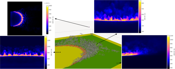
- Finally, the third step focus on using fire behaviour metrics, empirical flame model, and the simulated plume to build a 3D fire scene that includes soot, gas and aerosols concentration distribution. The scene is then introduces in the DART radiative transfer model with associated optical properties computed from the composition of the flame and the plume. DART is then used to render simulated IR images from the simulated fire scene. The image below shows DART simulated Middle Wave Infra Red images from the C064 fire simulation from the FDS fire model. The perspective view show the C064 scene at t = 55s, where the color code of the isocontours in the perspective view is: orange for heat release rate per unit volume of 1000kW/m3 , green for unburnt vegetation, and grey for soot volume fraction of 10−7. It is interesting to note the difference in fire peak temperature between the rear and the front view. This is due to absorption of the cool soot particles present in the plume.

Along this long term objectives that target large scale fire, we also work at smaller scale to build validation data set. To this matter for example we develop technical approaches:
- to monitor at high spatial and temporal resolution experimental fire conducted in CERTEC Fire Lab. For the validation of DART simulated flame, we recently conducted acetone flame experiment where we recorded simulateously at 30Hz or higher flame temperature using L-type thermocouples, mass loss rate using a scale, and Long Wave Infra Rad (LWIR) images using an Optris P640 camera.
- to compute ROS from small scale experimental fire smaller than 1ha from LWIR images collected at sub meter spatial resolution and 30Hz frame rate. For this we have been working on the development of a system to operate the portable LWIR P640 optris camera from a drone. Working with the Octocam company we equipped one of their DJI matrice 300 with our P640 camera controlled by a Raspberry4. See photo below of the mounted device. Test lights were performed in Ripollet, near Barcelona. Image orthorectification was run with the algorithm OrthoIrCam. A take off and a landing monitored at 10Hz is shown below.
References:
Paugam, R., Wooster, M., Atherton, J., Freitas, S. R., Schultz, M. G., and Kaiser, J. W.: Development and optimization of a wildfire plume rise model based on remote sensing data inputs -Part 2, Atmos. Chem. Phys. Discuss., 15, 9815-9895, doi:10.5194/acpd-15-9815-2015, 2015.
Paugam, R., Martin J. Wooster, William E. Mell, Mélanie C. Rochoux, Jean-Baptiste Filippi, Gernot Rücker, Olaf Frauenberger, Eckehard Lorenz, Wilfrid Schroeder, Bruce Main, and Navashni Govender. 2021. “Orthorectification of Helicopter-Borne High Resolution Experimental Burn Observation from Infra Red Handheld Imagers” Remote Sensing 13, no. 23: 4913
Share: